Civilization Is Thinning Out
Done with our battery upgrade in Georgetown, TX we are now off to more remote areas of Texas. Our first layover as we head south is Ozona, TX. Just a wide spot in I-10 but the RV park fits our needs for the night and the donut shop makes a great apple fritter. From Ozona we drifted a little further west to Pecos, TX. We'll spend four nights here at an Escapees park, using it as our base camp for day tripping to National Parks.
We're in a straight row of 14 pull-thru RV pads and we pretty much have the place to ourselves. We only had another overnighter twice in our four nights. Pecos is all about oil. There were dozens of RV parks, most of them with covered RV pads to protect the long-term residents from the scorching sun and fierce wind, and they were full. Then there are the thousands of tiny homes and work camps with barracks-like living quarters. All catering to oil field workers.
Tra-Park, an Escapees members park in Pecos, TX is centrally located for our sightseeing purposes. Carlsbad Caverns and the Guadalupe Mountains are about an hour and a half north of us and Fort Davis and the Davis Mountains are about an hour and a half south of us. We're revisiting some favorites and adding new experiences.First up, Carlsbad Caverns National Park, NM. The drive was pleasant but it was an hour and a half of long, straight, flat roads. Nothing to see for as far as the eye could see except for drilling rigs and pump jacks. Of course this is the kind of environment Cyndee and I grew up in. The dust is less red this far south but other than that it felt like our childhood home.
At White's City is where you turn off the main road to enter Carlsbad Caverns. White's City does not fit its name. The place consists of one gas station, a convenience store, trinket shop and cafe. As we eased past the "city" and approached the entrance to the park Cyndee was looking up a hill to her right and said; "Those bushes are moving!". We stopped right there in the middle of the road, there wasn't another car in sight, and took a closer look. Those bushes turned out to be Bighorn Sheep, all of them with their heads down, grazing.
 |
| With a little help from a 300mm lens those moving bushes proved to be Bighorn Sheep. |
 |
| Park Entrance at bottom of a canyon. |
 |
| Got to drive to the top of the mesa to access the caverns. |
 |
| The visitor center sits atop the mesa, adjacent to the natural cavern opening and houses the elevator shaft that descends 750 feet to the Big Room. |
We've been to Carlsbad Caverns more than once. Those trips down into the depths of the underworld have always been interesting. But experience has taught us that if the elevators are not fully functional you need to be prepared for a very long (2 hour) wait for a ride to the top, hike up and out the natural opening or not go down at all. Neither of our knees are up to the long hike out and they were down to just a single elevator operating so we chose to not enter the caverns this time.
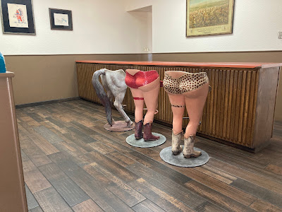
On the way out of the park we popped in to the cafe in White's City and had a $15 hamburger. Just off to the side of the entrance lobby is what I think is a bar. It was very spartan on decor with the exception of its barstools.
 |
| Creative barstooling? |
The oddities of the shape of the park have you entering, exiting and reentering the park along the main access highway. Hence the two entrance signs. One thing we noticed both in Carlsbad and now in the Guadalupe Mountains is how green everything is. In all our times of being in the area or passing through it has always been brown in all directions and all elevations. Seeing everything green is a unique experience for us.
 |
| We've been around Ocotillo for years at a time and have seen them with leaves and blooms but never have we seen Ocotillo with densely packed, dark green leaves like this. |
The house, originally built by two brothers in the 1870's just consisted of the front rooms. They sold the ranch to a family in 1906 and over a 34 year period they added a kitchen, two bedrooms and an upstairs. They also converted the ranch to a truck farm, hauling fruits and vegetables 60 miles away to Van Horn. A jolting wagon ride that was done overnight to protect the produce from the heat.
This little outbuilding off the rear corner of the house lived many lives. It was a bunkhouse, a barn, a storage room and ultimately a schoolhouse for 8 children. The Smiths, the owners beginning in 1906, paid a teacher $30/month, room and board and access to a horse.
The spring that ran just outside the front door is what made living here possible. It was a reliable source of water and pointed to an aquafer that the Smiths tapped with a well and employed the first hydraulic ram pump used in the region. During my visit the spring was flowing at a pretty good rate. The top of the windmill was gone but the well was still in use via an electric pump.
The next thing around the bend was McKittrick Canyon and its visitor center.
I'm really taken with these ocotillo. Their dense leaf growth wasn't just in the Carlsbad area, it at least stretches south into the Guadalupe Mountains.
We also visited the Pine Springs Visitor Center and Headquarters. Disturbingly, not a single photo is on the camera's memory chip, in my phone or in Cyndee's phone. We know we took them, they seem to have just evaporated into the ether.
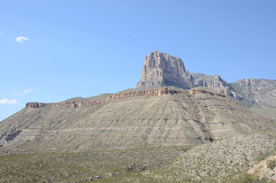
From Pine Springs we headed south to start the loop back to Pecos. Highway 62 is pretty scenic in that you can watch Guadalupe Peak for a good number of miles.
The drive back to Pecos, via Van Horn is going to take about two and half hours. It would be faster if we backtracked our route but we'd rather see new sights. The new sights turned out to be vast, flat, desert plains. The only notable thing we came across was the heavily secured entrance to Blue Origin, Jeff Bezos' space port.The big sign looks friendly enough but the actual entrance looks just the opposite.From this gate to the launch facility is approximately 10 miles. And from this gate to Van Horn, nearest town, is about 24 miles. Bezos has got himself some serious isolation.
Passing through Van Horn to get on I-10 took about 2 minutes. If you blink you'll miss town. We'll head east on I-10 until it branches to I-20. An interstate ride at 80 mph all the way. As we approached Pecos from the west we could see storm clouds building in the east, apparently right over Pecos. As we got closer we could see the storm was building from the south, moving north. It looked more and more like it would cross I-20 directly over the top of Pecos.
Just as we approached the city limits of Pecos this happened:
 |
| Image capture from Cyndee's dashcam. |
Ever seen a dirt rainbow? Click to play dashcam video.
Okay, the video is not launching from the blog page. Something about Google not playing nicely, even though Blogspot is a Google product! So instead here is a link that will play the video.
We're calling it a day. Tomorrow will be another long day in the car as we go to Fort Davis and revisit favorite places.


Comments
Post a Comment