Monday, June 30, 2014

Visitors to the North Rim of the Grand Canyon are so Entertaining.

Grand Canyon National Park, what an awesome, inspiring and breath-taking place.  But it is a park divided, the South Rim is convenient to a major interstate highway, has a railroad and runs shuttle buses up and down popular view points for fourteen hours a day 365 days a year.  The South Rim has a multitude of lodging options, I-MAX theater, and you are within minutes of well stocked grocery stores and restaurants.  The digital age has found its way to the South Rim as well.  This ease of access and facilities on a year around basis draws five million visitors a year.  A mere ten miles away, as the raven flies, is the North Rim.  Buried in ten feet of snowfall during the winter it is only open from mid-May to mid-October.  There is no interstate or major highway even remotely close.  A trip to the North Rim is not a visit of convenience, it is a place that you need to make plans to get to.  Basic services are Spartan at best.  There is the North Rim Lodge with it rustic cabins, there are no rooms in the lodge itself, and its dining room with gourmet prices for mediocre dishes.  I once got a pasta dish that had marinara sauce that was little more than ketchup with Italian seasoning sprinkled in.  But the other side of the coin is that I could make an entire meal off of their miniature bread loaves with chunks of garlic in it and an olive oil and herb dipping sauce.  Wuf.

Let me get back to making the point of this post.  The North Rim may be only ten miles from the South Rim but they are worlds apart.  Everything on the North Rim is a smaller scale and advances in civilization lag a good twenty years behind.  The remoteness of the place is the biggest factor in all this.  To drive to the North Rim from the South Rim is a solid five hours, if you can do it non-stop.  From Flagstaff it is 4.5 hours, Las Vegas 6 hours, Salt Lake City 7 hours, Phoenix 9.5 hours, Las Angeles 10 hours.  You just do not casually decide to pop over to the North Rim for a look-see.  It would be most difficult to drive in from any major population center and do more than just turn around and go back as a day-trip.  If you are to see or do anything on the North Rim it requires an overnight stay.  And most of the 500,000 visitors (one tenth of the visitors to the South Rim) do it that way, either staying in the lodge or campground, but since those spaces are few, many stay at lodges and campgrounds that are in the National Forest 20 miles away, adjacent to the National Park or 45 miles away in Jacob Lake.  And then there are those that want to stay "in town" and will day trip from our closest one, Kanab, UT 85 miles away.

The scenery on the North Rim is different too.  From the south side the Colorado River is visible from virtually every viewpoint, from the north it is a real chore to find a place you can see it at all.  The north side is a couple thousand feet higher than the south and the Kaibab Plateau that forms the north side of the canyon is heavily wooded with giant ponderosa pine and aspen trees.  The south is more desert-like in vegetation and temperature. 

View from the South Rim.
Colorado River almost always in view.  Scrub oak & juniper prominent.
See the cliffs sticking up in the distance?  That's the North Rim.
View from the North Rim.
No river in sight.  The South Rim's plateau is a couple thousand feet below in the distance.
Ponderosa pine, aspen and fir everywhere on the north side.

Highest point on the North Rim and entire National Park.
Both north and south rims line the 277 miles of river within the National Park.  The stretch of river within the park affords river rafters trips that last from one to 10 days of a combination of gentle floating and heart-pounding rapids.  The South Rim Village and the only place you can drive to on the North Rim lie approximately mid-way of the river that is book-ended by Lake Powell (Page, AZ) to the north-east and Lake Mead (Las Vegas, AZ) to the south-west.  Try this link if you want to see a map of what that looks like.

I hope by now that I have provided an adequate amount of description to convey the vastness of Grand Canyon National Park and the contrast between the north and south rims.  If I have, you will enjoy the anecdotes to follow.

Already, just in these few, short opening weeks of the North Rim we have had a number of visitors that have had difficulty in grasping the scale and remoteness of where they are.  And it has not seemed to matter whether the visitors are from distant continents or within the contiguous 48.  Just this week we had two of the biggest class C motorhomes I have ever seen pull up to the registration kiosk.  The passenger of one of the rigs got out and came to the window, reservation in hand.  You could tell it had been a long day, or maybe a long week.  Fatigue was clear on her face.  She handed me her paper work and I cross-checked the name on her reservation with the master list for the day.  I could find no match. When I looked at the paper she had handed me more closely I asked her where she thought she was.  "Mather" was the reply.  Mather campground is one of several campgrounds on the South Rim.  It took three attempts to get her to understand where she was and when she finally did she said; "Oh well, it is only ten miles to the other side according to the map.  How do we get to the bridge that goes across?"  When Cyndee and I finally convinced her that there was no bridge she began to return to her rig but was met by the driver of the other rig.  From our window in the registration kiosk we could see a passionate discussion ensue, first with hand gestures and then arm gestures with lots of upper body movement.  The face on the driver of the other rig changed from questioning to mouth-open disbelief and then to realization and fuming mad.  That is when the conversation became loud enough to be heard.  I don't speak German but I am pretty sure that the words he was spewing in the direction of the driver of the first rig contained a few that would have got my mouth washed out with soap around my house.

After a pow-wow in the lead rig and a close scrutiny of maps with retracing of their steps they discovered that they had made a wrong turn at the one and only intersection on the route that goes south out of Page, AZ.  The road from Page connects with AZ 89A a good number of miles south of Page.  You either go right (north) to Marble Canyon and eventually Jacob Lake (the gateway to the North Rim) or left (south) towards Flagstaff and eventually the South Rim.  Now, fully grasping their situation they were returning to our window asking if there were any campsites available.  They did not receive the news very well that every site was booked six months in advance and that there we no cancelations for a single site let alone two.  It was late in the day, the sun was setting and the hordes of deer would soon be coming to the road's edge to graze.  They were looking at a minimum 45 mile drive and playing deer dodge the whole way with two huge class C's.  And they would need a good amount of luck to find a spot open at Jacob Lake.  Chances were pretty high that they would have to go all the way to the South Rim so they could get access to the sites they have reserved.  If they were lucky they may make it before the sun comes up tomorrow.

Another evening at the registration kiosk we were approached by a family.  The dad leaned into the window and with obvious frustration wanted to know where all the water falls and lakes were.  "We have been all over, taken every paved road (there are only three in all of the North Rim) and can't find any signs pointing to the water falls and lakes", he said.  For a moment I was like a deer in headlights, trying to process what he was asking.  Cyndee reached over and pushed up on my chin to close my mouth and all I could think to do was ask they guy; "What water fall"?  He began waiving his hands and gesturing broadly saying; "You know, the lakes.  The big water falls."  Then he finally said something that sounded like he was talking about Lake Mead.  And with that little bit of information we could imagine that the falls he was asking about might be Havasu Falls.


We explained that both of those outdoor wonders were best accessed from Las Vegas but since he was already at the North Rim the drive, at least to Havasu Falls, would be shorter now if he went via Flagstaff.  And regardless of which way he went he had at least eight hours of driving ahead of him.  At that point he confessed that; "We have been watching too much TV".  Evidently they had watched a nature program that did an aerial tour of northern Arizona, and since it only took an hour to watch they thought all the sights they had seen on their small screen could be driven to and viewed in about the same time!  Seriously, did no one get out a map and even make a casual estimate of the distances involved?  Oh, and by the way, after you drive eight to ten hours it is a multi-hour hike to the falls or a helicopter ride if you can afford the luxury.

Sadly the answer is no, and not just by this family.  We have stories like this being repeated almost daily now.  And that is just the ones we hear about, there are bound to be a bunch we never know about.

Sunday, June 22, 2014

Grand Canyon, Condors & Cameron

We have been on our summer assignment a little over a month now and have yet to get out to any of the places to see the canyon.  Our days have been pretty full with our routine work schedule and then there has been the extra training we have been getting.  We both got our certification to touch government computer keyboards and have our very own nps.gov email accounts now (ooohhh).  Then there has been the short road trips to see non-Grand Canyon attractions.  But we have changed that as of late.

Just as the season was finishing up last year, the road to Cape Royal was closed so they could re-pave it.  It is a popular place for visitors to the North Rim to go and one of the few places that one can get a glimpse of the Colorado River.  The North Rim has a couple of rows of buttes between it and the river that keeps the sculptor of the canyon hidden.  For our first canyon outing we thought we would go try out the new road and see if they smoothed out the heaves and dips of the old road, or better yet, widened it a little bit so you don't have to fold your mirrors in to keep from hitting the other person's mirror coming from the opposite way.  I guess we expected too much because when we got there the only difference we could tell was that the asphalt was new.  It did not seem an inch wider but maybe the heaves were not quite so high or the dips quite so deep.

Even though we were returning to familiar places there was still a lot of wow factor.  Just being away seven months our senses had forgotten what it was like that first moment your eyes take in more beauty and grandeur than they can handle.  The walk up to the edge of a 3,000 foot vertical drop was just as big a rush as the first time.


Arriving in August of last year we did not see the early blooming plants, as it turns out we did not miss much.  There just are not that many plants up here that bloom in the early, dry part of the season.  Everything seems to wait for the monsoons to start in mid to late July.  But there is one flowering plant with roots so deep it does not care, the Cliff Rose.  It looks like a scrub juniper tree but it is actually a member of the rose family.  And like its name says, it is found near the cliff edges in many places on the North Rim.  On our way to Cape Royal this day we found them easy to spot as they were all profuse with blooms.

Cliff Rose.
From a distance they appear similar to a juniper.
As you get closer the white masses become distinct clumps of flowers.
The Cliff Rose with its four white petals and yellow stamens.

Seeing the blooms was nice but not what we came for.  Our objective for the day was to get to overlooks and get some quality hang-time over high precipices.

One of the few places that the Colorado River can be seen from the North Rim.  If you squint just right you can see it at about the 8 o'clock position.

I don't know why but Cyndee wanted to take these pics.  She kept saying; "get farther out". 
While out on the rocky ledge I spotted a lone flower poking up out of the gravel.  Don't know what it is but it struck me how something so delicate looking could make a go of it in such a harsh place.


In addition to our sight seeing we were also in dire need of a full grocery run and an in person visit to our bank.  The need to physically be at a bank dictated our destination for grocery buying.  Bank of America has bailed out of every reasonably close town, turning their branches over to Wells Fargo or Bank of the West, with the exception of Flagstaff.  Flagstaff, if you do not stop along the way, is a four and a half hour drive from the North Rim.  We decided to not kill ourselves by taking on nine hours of driving and a full day of shopping all at once.  Instead, we booked a one night stay at an extended stay hotel and split the shopping, banking and driving across two days.  The extended stay room gave us a fridge and freezer to keep stuff in, not to mention a comfortable respite from a howling wind storm.

In the days leading up to and during our entire trip to Flagstaff the wind blew relentlessly.  Steady blowing of 40 to 50 mph with gusts and micro-bursts exceeding 70 mph.  In places where there was little vegetation, like around the Vermillion Cliffs and the Tuba City area, great clouds of red dirt rose thousands of feet into the air.

On our way out of the National Park we were hoping to see the buffalo herd.  We had learned that because of the lack of winter snow and mild temps that calving season saw nearly a 100% survival rate.  Between the lack of snow moisture and the increase demand for grazing, the meadows inside the park had give out and the park service had resorted to feeding the herd.  When we approached the entrance station we were not disappointed, the whole herd, all two hundred and fifty of them were spread out before us.


They were strung out so far that I could not get them all in even with a wide angle lens so I took the above panorama with the iPhone.  You can't really see much but it does convey a sense of the scale of things.  I would guess that 80% of them were laying down.

You might also notice that I am keeping a good distance between me and them.  These guys can get an attitude on pretty quickly and become aggressive.  Their horns, which they all have regardless of gender or age, can shred the sheet metal on a vehicle in a heart beat.  And since they can run at 35 miles an hour you need plenty of room between you and them for reaction time.  That's where a good telephoto lens comes in handy.

Buffalo herd in the meadow just inside the National Park Entrance Station

Everybody had an impressive set of horns.
Moving on, we make our way down off the Kaibab Plateau, losing about 3,000 feet in elevation.  As we finish our first hundred miles Big Gulp is reporting a fuel consumption rate of 23 miles to the gallon, way above its single digit rate of 8 mpg when towing the 5th wheel and nearly twice that of its normal running empty rate.  But this improved fuel economy is not all due to downhill travel.  The wind I spoke of early is in our favor too.

While the wind was a benefit for locomotion the first half of the trip it put a bit of a damper on one of our favorite things to do on the way to Flagstaff; stopping at Navajo Bridge and photographing Condors.  When we arrived there were no birds to be found but after scanning the skies for awhile one appeared in the distance.  He was waggling significantly, trying to stay his course and reach a roost near the bridge.  I double-wrapped the camera strap around my upper arm for fear the wind would peel the camera from my hands and leveled the lens in the direction of the approaching black kite.

As the condor came in he was flying directly above and parallel to the river gorge.  As he approached the bridge he turned perpendicular to the river and headed for the canyon wall opposite of where I was.  Now he was jinking and jerking hard, trying to stay lined up for a landing.  Then, suddenly, he turns 180 degrees, flying just below the trusses of the bridge and looking for an alternate runway.


Condor 40 has picked a place to land.  He is on final approach, flaps down, gear down.

He is over the threshold now, starting his flare-out.  Wind is swirling in all directions.

And he sticks the landing!  A perfect two-point with a three step roll out.

I think he impressed himself with that landing.
We are getting pounded by the wind and there are no other birds in sight so we move on to our next anticipated stop; Cameron Trading Post.  I wrote about this place last year and carried on about their restaurant's house specialty; Indian Fry Bread Taco.  We had deliberately timed our departure so that we would arrive at Cameron during lunch time.  And we purposely skipped stopping at Jacob Lake for one of their world famous cookies to be sure that our appetites would be peaked.  And they were.

As a first-timer, if you order the regular-size taco you are shocked at the enormous plate of food they set before you.  Last year I had to be carried out of there in a wheel barrow after I finished the whole thing.  This year we took a much more sane approach and ordered a single taco and split it between the two of us.  It was still more than enough to make each of us uncomfortably full.  Maybe that side order of fries I asked for had a little to do with it too.

Aside from the restaurant and its fry bread taco, Cameron is a heck of a stop.  It is a trading post, motel, museum, post office and gas station.  The trading post is large and heavily stocked with everything from made in China trinkets to local artist hand made jewelry, much of which is museum quality.

Cyndee inspecting some of the Navajo artist, hand made turquois and silver jewelry.

Even the architecture of the restaurant is worth stopping and seeing.  Hammered metal ceiling, stone columns, huge carved display cases.

There is a rug weaver that has a loom set up in the trading post.  Every rug hanging in this display is priced at more than $10,000
Once we crossed the Navajo Bridge the road turned and pointed us into the wind.  Now we were climbing and pushing a head wind, the fuel economy numbers dropped rapidly.  Our chores in Flagstaff went without incident.  However one thing happened that I had not experienced since I was a youngster growing up on the high plains of the panhandle of Texas.  While pushing a fully loaded shopping cart to the truck a gust of wind came across us that was so powerful that it pushed me (and the cart) back a couple of steps.  It had to be a heck of a gust, I was already braced and leaning into the steady wind and still I was pushed back.

Even with the wind it was a nice trip.  Getting a hotel room for the night was a good thing to do for several reasons.  But our kids are coming to see us in August and we will do that one as a day trip.  We have told them to get a plane that arrives early enough in the day that we can stop at Cameron for a taco on the way back and still be daylight enough to not have to dodge a thousand deer before getting home.

Thursday, June 19, 2014

Runnin' the Traps

It has been pretty steady of late.  Cleaning fire pits, filling flat tires, jumping dead batteries; just the usual.  We have however been getting trained to operate the check-in kiosk.  Sounds simple but as with all things government, it is anything but.  This means that we have to get 'certified' to push the keys on a government computer, which entails two hours of on-line testing and then a waiting period for our account to be approved.  THEN we can actually get trained on how to use the camper registration system.  We both aced the testing by the way.  Which I gather is not always the case based on all the procedures they have for reattempting the testing.

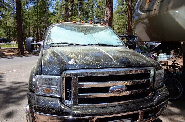
A little something different is that tree pollen season is in full swing.  And since we have massive amounts of giant ponderosa pine trees that means massive amounts of pine pollen.  Having spent the last 30 years in the Atlanta metropolitan area, an area heavily wooded with pine trees, we thought we had seen what layers of pollen looked like but were shown what we did not know by the pine trees on the North Rim.


Pine pollen piled up like I have never seen.  Big Gulp was covered in just a matter of hours and not just the flat surfaces but the vertical sides, inside the grill, inside the cab, everywhere.  The camper was just as covered and pollen found its way onto all surfaces inside too.  And this ponderosa pine stuff is sticky too.  It does not just blow off when you get in and move down the road, no, it takes a fairly vigorous washing to remove.  We'll probably be cleaning pollen out of the camper for weeks to come.

The pollen has developed a layer so thick on the ground that each footstep you take creates a little explosion of yellow.  Everybody becomes a version of Pig Pen from the Peanuts comic strip as they walk through the campground.  Its a real mess when a gust of wind comes through.  Huge clouds of pollen get airborne and hang there for far too long.

But the routine goes on.  And it is time for battery maintenance on our all electric ATV.  The Polaris has six king-size lead-acid batteries and the charger hits them pretty hard.  They need to be replenished with water about once a month.  Being buried under the seat makes the job tedious and some of the cells have to be done almost blind as they are tucked up under the seat frame.

Our electrician in residence, Jude, is taking care of us.  He has us stocked with over six gallons of distilled water and industrial grade personal protective equipment; rubber gloves that have cuffs that almost reach my armpits, a full length rubber apron and goggles.


Oh, and a turkey baster, THE essential tool for filling each cell to its proper level.  Three gallons of distilled water and an hour later and our scheduled maintenance on the Polaris is done.  Ed, our co-host, helped peel me out of the rubber protective gear so I could begin drying out.  Rubber does not breath very well and I looked like I had just gone swimming fully clothed.

Seemingly timed with the arrival of the pollen, butterflies have appeared.  Most of them have maintained a distance and been on the move to a degree to thwart being photographed.  But at least one got in range of the lens.  I'll leave this post with its portrait.


Wednesday, June 18, 2014

Pipe Spring National Monument

On our first days off in June we decided to combine a lite shopping trip with some sight seeing.  Kanab, UT is the closest place, at 85 miles that has full service grocery stores (2 of them) and enough places with diesel fuel to spur a little competition and get the price of a gallon below $4.  A few miles west of Kanab is a National Monument called Pipe Spring.  We never made it to this attraction last year so we thought we would give it a try this time.

Pipe Spring National Monument started out as ranching operation, pioneered by the Mormons.  Of course the spring was the life blood of Native Americans for hundreds of years before the Mormons arrived.  But it took the Mormons and their construction of a fortress over the top of the spring to forever change the surrounding desert from being a sustainable provider to a near wasteland.  The Mormons ran the operation as a tithing ranch, receiving thousands upon thousands of sheep and cattle they received from their parishioners and grazed on the then plentiful prairie grasses.  But the high desert could not keep up with the demand of the domestic herds and soon the grass was gone and unpalatable sage took over.

Like many of our National Monuments, Pipe Spring nearly dissolved into the sands of time before the Park Service took possession (in 1923).  Even then, many of the structures continued to decline for another seventy years until money finally found its way to this tiny, remote outpost in the '90s.

The visitor center has an impressive museum that does an excellent job of portraying the history of Pipe Spring and surrounding area.  And there is a guided tour every half-hour of Winsor Castle (the tiny fortress built over the spring), which is what made the trip worth it to us.  It is about the only structure left that has original construction in it and although it has been refurnished to period, none of it is original with the exception of one piece, the cast iron stove.


I'm not sure why, but I was really taken with this stove.  It had so many features - a hot water tank, bread box, kettle warmer, flue controls and drawers and compartments that I don't know what they are.  The place that built this thing must have been really something and it must have been one heck of a wagon that got it to where it is.

Back in the mid-1800's people were not really clear on where the border between Arizona and Utah fell exactly.  When the Mormons built Pipe Spring it was generally accepted that they were in Arizona.  They also became part of a project for connecting the country by telegraph and soon they were one of many stations that would receive and then relay messages.  The telegraph operator was almost always a late-teen, early-twenties, single female.  The room for the telegraph office and her bedroom were one and the same.  And at that time that was a perk.  The telegraph operator was the only person in the whole complex that had a private living quarter.

The Mormons operated Desert Telegraph, later discovered to be the first telegraph in Utah.

The telegraph wire came right off a glass insulator nailed to the outside wall and through the window to the operator's private living quarters.  Check out how thick the window sill is.  These walls were built to keep out the blistering summers and deep freeze winters.
At some point surveyors got around to clarifying where borders were and much to everyone's surprise at Pipe Spring they found that they had never left Utah.  Their entire operation was within the state of Utah and now they had also become known as the first telegraph operation in the state.

The "fort" courtyard was just big enough to hold a single wagon.  Large, heavy, wood gates were at each end that allowed them to load/unload wagons fully protected.  The irony is that the fear of attacks from marauding bands of Indians never materialized because by the time they completed the construction of the fort there were no Indians left.  They had all been defeated and moved to reservations.  But they did sustain a certain level of paranoia about government interference because of their views on bigamy.  The fortress mentality remained.


In our touring of the grounds and facilities we found we had constant companions; lizards.  They were everywhere, you had to watch where you stepped for fear of squishing one of them.  They were inside, they were outside, they were everywhere.


It has been a few hours since we arrived and the sun is high and hot now.  The lizard in the photo above is alternating lifting feet off the hot surface.  We are going to make the 14 mile drive to Kanab and get our groceries and head back to the cool climes of the North Rim.


What do you drive on vacation?

Cyndee and I went to the Lodge the other day to attend a presentation by an "Artist in Residence".  We were going to watch him fuse glass to metal with the final product being a fine piece of art.

But first we had to walk the length of the very long Lodge parking lot.  A little something we like to do is look at all the license plates and see where everyone drove in from.  We see plates from all over, even ones from places that they could not have possibly driven from such as Hawaii and several countries in western Europe.  But on this day a couple of cars behind the plates caught our attention.

One, a favorite of Cyndee's, was a Ferrari Testorosa.


And then there is this:


A 1930 Bentley.

Keep in mind that it is not just a Sunday leisure drive to get to the North Rim.  Six hours from Las Vegas, five hours from Flagstaff, nine and half from Phoenix, and eight from Salt Lake City.  Nope, not just a spur of the moment decision to drive to the North Rim.  A Ferrari is not exactly a luxury ride, it's focus is on being a street legal race car and the Bentley is a slow ride in an open cockpit through wind-blown sand and barely filtered sunlight at high elevation.  These folks really want to drive their pride-and-joy's.  Can't say I blame them, either one of these would be a cool way to do a road trip.

Thursday, June 5, 2014

Gotcha

In photographing our surroundings Cyndee and I have captured tiny lizards scurrying across the desert, raptors nesting and on the wing, hummingbirds darting around, bears on a mountain, deer and turkey picking their way through dense forest.  But one critter that has eluded our camera is the Kaibab Squirrel.

The Kaibab Squirrel is rare, existing only on the Kaibab Plateau and then only where the ponderosa pine grow.  The population of them is pretty high in North Rim Campground but you could not tell it by the photos taken of them.  These squirrels are wary of anything that moves and keep themselves at distance from anything not a ponderosa pine.  Even when they do finally come down to forage they are in constant motion, making it near impossible to get them framed up and a good lock on focus.

After three months of chasing them around last season I have several dozen photos of blurry, gray shapes.  And even when I got close enough to use a flash to "freeze" the action, the results wear unappealing.  Don't ask me why but the harsh light of the flash made them look like devil-spawn.

But perseverance pays off.  And being lucky enough to be in the right place at the right time helped a lot too.  We have a squirrel that must have nested in a tree this winter directly across the street from our campsite.  Cyndee had been noticing him making routine visits to the ground to dig up some of his cache.  And doing something not typical, sitting right there and eating it.

So during one of our lunch breaks I got the camera out when we saw him coming down his tree, right on schedule.  He dug up a big nut he had buried months before and much to my surprise sat right there and began eating it.  I started snapping shots from a long way off but moved one step closer with each set of frames.  FINALLY, after all the too distant, too blurry, too dark and too just no good shots, I finally got a couple I am not embarrassed to post.

Kaibab Squirrel
Tufts of hair on ears is a winter thing.  It will all be gone by the end of June.

When moving through the forest the body of the squirrel is almost invisible but the tail is highly visible as it undulates along.  We tell visitors to just look for the dinner napkin moving along the ground to find a squirrel.
Another critter that I have been less than successful at capturing is the Majestic Hummingbird.  I displayed a shot in an earlier post but it was not much better than a silhouette.  We soon found that, like the Kaibab Squirrel, the hummingbird had a routine too.  He seemed to pass through each afternoon at about 3:00pm.  With camera on tripod and pointed in the general direction of one of his stops, I waited.  If he appeared all I would have to do was push the shutter button.

Like clock-work he showed up.  I reached up and held the button down, shooting 5.6 frames per second hoping that he would move into the direct sunlight for at least one shot.  And he did, sort of.

In his ten second appearance I peeled off 50 frames and this is the only one worth sharing.
He briefly moved into light, enough so that the blue on his throat lit up and some green on his belly began to show.  But he never turned his head just right to show off the intense purple cap on his crown.

The turkey that were so plentiful last season have not been seen so far.  On our next days off we may go to a couple of the little clearings and meadows we know about some five miles away to see if we can track them down.

Wednesday, June 4, 2014

Fire on the North Rim

It started a couple of weeks ago.  If you had read one of my earlier blogs where I wrote about thunder snow, it was one of the lightning strikes form that storm that started what is now called the Galahad Fire.

It started small and stayed that way for about a week, just a couple hundred acres.  But in the past week it has intensified and grown to almost two thousand acres.  The National Forest Fire Service has been building fire breaks near an historic cabin and fire watch tower and doing ping pong ball napalm drops with helicopters to start back-fires.  Up till now they have not been actively trying to extinguish the fire, just control where it is going as long as it continues to progress as a beneficial fire.

The idea was to keep the fire west of a forest road known as Point Sublime Road (aka W-4).  As long as it stayed there it would burn to the west and toward the edge of the canyon where it would run out of fuel.  But the plan is to begin active fire fighting if it jumps the road and starts coming east, towards the campground.

The fire has approached the road close enough that it is now closed.  It is a pretty popular road with the four-wheeler crowd so there is a bump up in the traffic on the remaining open forest roads to the east as people seek out other places to play.

In the last 48 hours there have been high winds out of the west and it has blown embers across the Fire Service's boundary and started four spot fires.  Up until now the fire was just a nuisance, causing smoke to hang heavy in the trees, burning the eyes and throat.  But now it is getting a little more tense.  Quietly, talk is beginning about evacuation procedures.

But on the bright side, we sure are having some pretty sunsets.  Smoke in the air makes for some really red and orange evening light.

Looking west across the Transept Canyon.

So far, staying isolated and deemed a "beneficiary fire".

On this evening, the wind is in the direction to keep the smoke out of the Grand Canyon
An irony in all this is that the National Park has not banned campfires.  The Forest Service lands all around us have, but not the National Park.  People are still coming into the campground and building, what looks to Cyndee and me as way too large fires.  But the way the wind has been blowing the last few nights, any size fire is too large as far as we are concerned.  And to top it off, we have cleaned out more "hot" fire pits in the last two days than we did in the whole three months of last year's tour of duty.  People are leaving fires burning and just driving away.  There will be no evacuation fast enough if one of our campers lets a fire get away from them.