Maverick Road
Within Big Bend National Park is a network of dirt roads. Some of these are listed as improved roads and can be driven by just about any vehicle, as long as it is understood that the going is slow and that your vehicle needs to be in good working order with plenty rubber on the tires.
For our project day, Cyndee and I checked out a high clearance vehicle for a day of back country road patrol. We were starting with the 13 mile long Old Maverick Road on the west side of the park. Our start was early because this part of the park is quite barren and looks best in early morning (or late afternoon) light. At this time the desert colors are more saturated and the feel of the desert badlands is less harsh than in the midday sun. The road crosses Alamo Creek and ascends the gravel hills between Burro Mesa and the Rattlesnake Mountains. Before the park was established this area was much different looking. After over grazing, farming and tree cutting for the mining operations there is little left to remind one that this was once grassland with thickets of cottonwood and willow.
Parts of the road are more than two lanes wide but in spots it narrows down to one, rocky lane. And most of these rocks were sharp-edged, the reason you want tires that are in good shape.
A little farther down and we get alongside a rocky cliff on the one side and plenty of washboard on an otherwise well kept road.

But while I was eye-balling the geology on my side of the car, Cyndee had spotted something altogether different on her side.
We do not know how old this grave is or who it belongs to. We have heard of many of these lonely grave sites and there is a number of bonafide graveyards as well. We have one that we have scoped out for later investigation. Maybe on our next project day.
A few more miles on and we came to a marked exhibit, a preserved dwelling. Senor Gilberto Luna built this jacal (ha-kal) and lived in it for many decades. Luna lived and raised a family, a very large family in this jacal until his death in 1947 at the age of 108.

The structure was built from materials on hand at the time. Large cottonwoods provided the beams and surrounding hills the rock, aggregate and mud for the walls. It was a long, single room and the height at the peak was barely 4 ft. But somehow this worked for Gilberto Luna and his reported 52 children. That's right, 52 children.
It is amazing that you only have to take one step inside and the temperature drops by about 20 degrees. It must have been something to see back when there were mature trees all around, plentiful grass for grazing cattle and productive farm plots.

The roof, like the rest of the structure was built from what was available but it is most unique to this area. Luna used what is known as "wattle and daub", a mud plaster applied to a lattice of ocotillo stems and cane grass.
A little further down Old Maverick Road is a turn-off that leads into what is known as Terlingua Abojo. There, the Park has established 3 car-camping sites. Nearby are some rock-structure ruins and, as an added attraction a long since abandoned vehicle. Left long enough ago that it has switched from being a piece of junk to an artifact. Disturbing it or removing any pieces will bring a $750 fine.
Back out on Old Maverick we are a lot closer to Santa Elena Canyon. And at this end of the road it is really good. It is similar to some unpaved county roads I have been on. If you didn't mind the rock chips, you could get up some speed on this.
But speed was not our objective. We were being looky-loos and out for the sights, not distance covered. Something that caught my attention was a single, giant yucca. This thing was on the verge of 30 feet tall and so "perfect" it almost looked artificial. I was struck by a yucca that was so tall and large that it was more like a palm tree than yucca.

By the time we came off Old Maverick it was almost noon and the light was once again of no use to me for photographing the canyon. We drove the 8 miles to Castalon where there is a visitor center and store. We took the opportunity to visit with our Castolon Visitor Center volunteer compadre and have lunch at the picnic tables in front of the store.
Although we had been here a couple times before, we had never really explored what Castolon had to offer. Even though we did this time, we really only scratched the surface. The buildings down at this southwestern most part of the park date back to turn of the century and earlier. The park has done little to change the way they were when they took possession of them in 1944. Roofs and paint was about it. As we walked around the General Store you could see the "old" in the shelving and sales counter but as I looked around a dark little corner I spied a moment frozen in time.

This old phone was not a prop. It was hanging right where it was installed nearly a hundred years ago.
Interesting as this place is, we have to go. We have to get to the river road on the east side of the park before the day is over. That will be the next post.
For our project day, Cyndee and I checked out a high clearance vehicle for a day of back country road patrol. We were starting with the 13 mile long Old Maverick Road on the west side of the park. Our start was early because this part of the park is quite barren and looks best in early morning (or late afternoon) light. At this time the desert colors are more saturated and the feel of the desert badlands is less harsh than in the midday sun. The road crosses Alamo Creek and ascends the gravel hills between Burro Mesa and the Rattlesnake Mountains. Before the park was established this area was much different looking. After over grazing, farming and tree cutting for the mining operations there is little left to remind one that this was once grassland with thickets of cottonwood and willow.
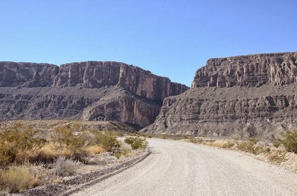
 |
| Old Maverick Road looking southwest towards Santa Elena Canyon. |
Parts of the road are more than two lanes wide but in spots it narrows down to one, rocky lane. And most of these rocks were sharp-edged, the reason you want tires that are in good shape.
 |
| Hard to picture this drainage full of cottonwood and willow. |
But while I was eye-balling the geology on my side of the car, Cyndee had spotted something altogether different on her side.
 |
| Unmarked grave alongside Old Maverick Road. |
A few more miles on and we came to a marked exhibit, a preserved dwelling. Senor Gilberto Luna built this jacal (ha-kal) and lived in it for many decades. Luna lived and raised a family, a very large family in this jacal until his death in 1947 at the age of 108.
The structure was built from materials on hand at the time. Large cottonwoods provided the beams and surrounding hills the rock, aggregate and mud for the walls. It was a long, single room and the height at the peak was barely 4 ft. But somehow this worked for Gilberto Luna and his reported 52 children. That's right, 52 children.
It is amazing that you only have to take one step inside and the temperature drops by about 20 degrees. It must have been something to see back when there were mature trees all around, plentiful grass for grazing cattle and productive farm plots.
The roof, like the rest of the structure was built from what was available but it is most unique to this area. Luna used what is known as "wattle and daub", a mud plaster applied to a lattice of ocotillo stems and cane grass.
 |
| Wattle and daub method used to make the roof of Luna's jacal. |
 |
| Terlingua Abajo campsites one and two were built on either side of this old truck. |
But speed was not our objective. We were being looky-loos and out for the sights, not distance covered. Something that caught my attention was a single, giant yucca. This thing was on the verge of 30 feet tall and so "perfect" it almost looked artificial. I was struck by a yucca that was so tall and large that it was more like a palm tree than yucca.
By the time we came off Old Maverick it was almost noon and the light was once again of no use to me for photographing the canyon. We drove the 8 miles to Castalon where there is a visitor center and store. We took the opportunity to visit with our Castolon Visitor Center volunteer compadre and have lunch at the picnic tables in front of the store.
Although we had been here a couple times before, we had never really explored what Castolon had to offer. Even though we did this time, we really only scratched the surface. The buildings down at this southwestern most part of the park date back to turn of the century and earlier. The park has done little to change the way they were when they took possession of them in 1944. Roofs and paint was about it. As we walked around the General Store you could see the "old" in the shelving and sales counter but as I looked around a dark little corner I spied a moment frozen in time.
This old phone was not a prop. It was hanging right where it was installed nearly a hundred years ago.
Interesting as this place is, we have to go. We have to get to the river road on the east side of the park before the day is over. That will be the next post.


Comments
Post a Comment