Road Trip – Glenn Canyon/Lake Powell – Page, AZ – Horseshoe Bend
Its Sunday of Memorial Day weekend, our first day off after
our second round of duty on the North Rim, cold and damp. Let’s blow this popsicle stand and see if we
can change things up a bit. Page, AZ is
only about three hours away; we’ll just pop over there and see what’s what.

We had both skipped breakfast in anticipation of an awesome cinnamon roll we are told they make. We tried to get one of these rolls last year on each of our trips out to do grocery shopping but every time we were either too earlier (we were told they would be ready in maybe an hour) or they were sold out. So with optimism we strolled into the Inn and eased up to the bakery counter only to be told, again, they should be ready in about an hour. I told the girl behind the counter that I was beginning to think that the cinnamon rolls were only a myth. Since she was new and had not seen us attempt to get a roll about a dozen times last year, she just blankly smiled.

I think the next time we get a wild hair to do something we are going to drive out to the Inn early in the morning and just camp out in the lobby until that hour that the cinnamon rolls will be ready in comes.

As we drop off the Grand Staircase and into Glenn Canyon, Lake Powell becomes a prominent feature in the windshield. But after driving for a while we realize that a lot of canyon we were enjoying used to be lake. The amount the water has receded is shocking. Side canyons that used to be flooded and afforded boaters and fish alike an enticing place to be with deep water and shelter from wind were again the dry canyons they were before the dam’s construction in 1957.


As we pull out of the North Rim it is in the upper 30’s with
not much promise of improving. But our hopes
of it being warmer in Page have us dressing in layers so we can pare down as
the day ages. Cyndee decided to forego
the thermals she had been wearing for the last week for the convenience of not
having to do a full change of clothes later on.
The route we are taking is totally counter to what the GPS
wants us to do. The GPS does not know that the road between
Marble Canyon and Page has suffered a quarter mile long avalanche and is
indefinitely closed. So, rather than
drive the southeast route along the Vermillion Cliffs and across the Navajo
Bridge before turning north to Page, we are going north to Kanab, UT and
traverse the Grand Staircase Escalante before dropping into Glenn Canyon. We are losing elevation almost the whole way
and Big Gulp is registering an all-time mpg high of 18.3! I’m sure we’ll be giving some of that back on
the return climb.
On our way out we stopped to reconnect with our friends that
run the Country Store which lies about 5 miles outside the entrance station to
the North Rim (which is 15 miles from where the camper sits). I bought just enough diesel, at $4.40/gal to
get us to Page where I hoped it would be better priced for a complete fill
up.
Next stop was 26 miles later at Jacob Lake Inn.
We had both skipped breakfast in anticipation of an awesome cinnamon roll we are told they make. We tried to get one of these rolls last year on each of our trips out to do grocery shopping but every time we were either too earlier (we were told they would be ready in maybe an hour) or they were sold out. So with optimism we strolled into the Inn and eased up to the bakery counter only to be told, again, they should be ready in about an hour. I told the girl behind the counter that I was beginning to think that the cinnamon rolls were only a myth. Since she was new and had not seen us attempt to get a roll about a dozen times last year, she just blankly smiled.
So, like last year, we got a couple of their six-grain
cookies and went on our way.
I think the next time we get a wild hair to do something we are going to drive out to the Inn early in the morning and just camp out in the lobby until that hour that the cinnamon rolls will be ready in comes.
Had an avalanche not taken out the primary road that we
would have normally used, the entire trip would have been within the borders of
Arizona. But taking this route “over the
top” has us wandering between Arizona and Utah.
Most of the scenery is high desert with brilliant red and white cliffs
in the distance.
As we drop off the Grand Staircase and into Glenn Canyon, Lake Powell becomes a prominent feature in the windshield. But after driving for a while we realize that a lot of canyon we were enjoying used to be lake. The amount the water has receded is shocking. Side canyons that used to be flooded and afforded boaters and fish alike an enticing place to be with deep water and shelter from wind were again the dry canyons they were before the dam’s construction in 1957.
The Glenn Canyon Visitor Center is pretty nice, perched high
on the cliff above the dam. It has an
interpretive display with the Lake’s namesake, John Wesley Powell featured
prominently.
 |
| Glenn Canyon Bridge with Visitor Center perched high on a cliff. |
 |
| Looking north towards Lake Powell. There should be a lot more water visible. |
 |
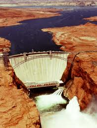
| Glenn Canyon Dam. At 710 feet high and 1,560 wide makes it the fourth largest dam in the U.S. |
In my shot above you can get a glimpse of the old water line, where the rock changes from white to red. The scale of this becomes pretty impressive when you realize that the clump of tiny dots on top of the dam are people.
I went on-line and was able to find some before and after pictures that give a sense of the change in just a few, short years.
That cookie for breakfast has long since worn off, time to
find either a BBQ or Mexican Food place a couple miles away in town. As we drove down the main avenue we found one
of each, side-by-side. The smell of the
smoker at the BBQ place made it an easy choice for which one to have. We pulled into Big John’s BBQ. Like any respectable BBQ joint, it was housed
in something that was built for anything else except a restaurant. In this case it is a former gas station. The pump island now serves as an outdoor
dining area and the driveway is home to the meat smoker.
Being this may be the only time we go to Page I could
rationalize my way into the $16 sample platter so that I could try all of the
meats. The brisket, pulled pork and ribs
were all good but I liked the spicy smoked sausage the best. However, I am pretty sure dinner will be out
of the question for me tonight, and maybe every meal tomorrow too. Whew, that was a lot of BBQ.
While at the Glenn Canyon Dam Visitor Center we learned the
road taken out by the avalanche is not completely closed. A little section from Page, south to the
Colorado River’s famous Horseshoe Bend is open and being used, heavily. It was only a few short minutes from our BBQ
extravaganza to the trailhead for Horseshoe Bend. Notice I said trailhead, we had always been
under the impression that this was a drive-up scenic overlook. Nope, not even close.
The walk to the overlook is three quarters of a mile;
normally a leisurely amount of distance but there will be no leisure about this
walk. The trail is deep, loose sand;
plenty hard to walk in on a flat surface, a vigorous workout to do it as a hill
climb. To get to the overlook we had to
climb up a ridge and then down to the canyon’s edge.
Only a short way into the climb, probably not even 75 yards,
Cyndee and I were both wishing we had done this before eating large
quantities of BBQ. We both kept scouting
for places off to the side of the trail to retreat to should our lungs win the
battle of using the space that our full stomachs were occupying. And combine that with the fact that it was
now 50 degrees warmer than when our day started, it was a real challenge to not
barf our brains out.
 |
| Cyndee getting started on her trudge up the sandy trail. You can tell by all the cars this is a popular place to be on Memorial Weekend. |
But the effort was worth it.
Horseshoe Bend is a beautiful sight.
 |
| Horseshoe Bend of the Colorado River |
While Cyndee has gotten much better at venturing out <near> the edge of high places, she was not quite ready to get close enough to the edge to get her picture taken, or to take mine with the whole horseshoe bend in sight.
 |
| What would a trip to a major tourist attraction be without getting your picture taken in front of it? |
 |
| That long-sleeved, dark-colored, canvas shirt was a poor choice for a day that topped out 50 degrees warmer than it started. |
The sandy climb back to the top of the ridge was even more arduous as the temperature had risen quite a bit just since our arrival. My heavy canvas shirt was pretty drenched by the time we got back to the truck. Time to crank up the A/C and make our way over to one of the marinas on the lake.
In just a few minutes we were driving into the Wahweap Marina area. In addition to the large and bustling marina there was a resort, shopping, visitor center, and camp ground. We drove around for awhile to get the lay of the land and take in a few sights.
 |
| Marina on the right, resort perched on the hill to the left. |
 |
| A prominent landmark visible for miles, even when shaded by clouds. Tower Butte |
 |
| Standing on the marina looking north. |
 |
| Tower Butte spotlighted by a break in the clouds. |
 |
| Cliffs in the distance that Cyndee called "other-worldly". |
 |
| Lone Rock has its own designated recreation area. Its use is relatively new as everything in the foreground used to be under 40 feet of water. |
 |
| A close-up of Lone Rock clearly shows the old high water line. This used to be the domain of fish and boats. It has been dry long enough now that trees have taken root. |
The day was getting late. We had a three and half hour drive ahead of us and we still needed to buy fuel and make a quick stop at Walmart before heading back.
It was worth the wait to get fuel in Page. At forty five cents a gallon less than what I could get it for anywhere else along our route, I saved $20 on a 43 gallon fill-up. We were also able to get a fresh vegetable at Walmart that we have not been able to find in the last three towns. Zucchini of all things. But as we went through Walmart the basket kept collecting more and more things that we didn't know we "needed". By the time we got our zucchini there was $115 of other stuff in there with it.
The drive home started later than we planned but we saw a fantastic sunset that we would have missed otherwise. Sorry, no pictures. The road was single-lane, no shoulders and we had traffic behind us. Nowhere to pull out and grab a few shots.
Like last year, we were hyper-aware of the multitudes of mule deer that would be along the roadside the closer we got to the park. And we were not wrong. As soon as we topped out the 2,000 foot climb from the Fredonia highway up onto the Kaibab Plateau there they were, lining the road.
Like last year, we were hyper-aware of the multitudes of mule deer that would be along the roadside the closer we got to the park. And we were not wrong. As soon as we topped out the 2,000 foot climb from the Fredonia highway up onto the Kaibab Plateau there they were, lining the road.
The next 65 miles was spent at no more than 45 mph with frequent stabs of the brake as grazing deer raised their heads and made motions in the direction of the road as we passed by. At least this night the buffalo were not strung across the road just inside the entrance station like usual.
We finally got close enough to home that we thought we were home free. But at one and a half miles from our destination we passed the Kaibab trail head. This trail head is THE trail head if you are going to descend into the canyon or climb out if you come from the South Rim. We are passing by at 10:00pm and notice a number of headlamps as we approach the entrance to the trailhead parking lot. It is not unusual for it to take people longer than they expected to make the rim-to-rim crossing so seeing someone this time of night was not a total surprise. But what got our attention was the headlamps all seemed to be pointed at us and bobbing in our direction. Just as we passed we could just barely make out forms. Were they waving their arms at us?
I rolled Big Gulp to a stop and took a moment to watch in the mirrors. The headlamps had definitely come out to the edge of the road and were still pointed in our direction. I began backing the couple hundred yards to get back to where the headlamps were. When we finally crept up to them there were two or three voices talking all at the same time. We were able to discern that a group of four had made the rim-to-rim hike but that they were too exhausted to walk the last two miles to the lodge where a friend was waiting to take them the 5 hour drive back to the South Rim.
The back seat of Big Gulp was full to the brim with our shed cold weather wear, groceries, coolers and travel paraphernalia. Cyndee drug a bunch of it up in the front seat with her and I stashed the rest in the bed of the truck. Four people piled in the back seat and for the first time we could see the faces of who we were rescuing. They were all twenty-something, two men, two women and ex-pats from India. In the short ride to the lodge I think at least one of them fell asleep.
But we got them there and left them to their own devices to find their ride back to their hotel. We still had a truck full of stuff and groceries to get in and put away before we could hit what is now a very attractive looking bed.
It was a heck of day for not having planned or researched any of it beforehand. We'll have to try this again.


Sometimes the unplanned trips are the best! JLS
ReplyDeleteLooks like some fabulous scenery.
ReplyDeleteHope you are having some time to relax and enjoy it! Have a fun summer in the canyon.
My compliments to the photographer!
JMM in suburbia... Blah!